Sunday, October 18, 2009

Cycling in Copenhagen


We're in Copenhagen for the Velomobile Seminar (posts to follow), but also spending a few days biking around the city. Here's where we rode on Sunday, October 18:


Bike route 338766 - powered by Bikemap

The tour took us from our hotel, the Quality Airport Hotel Dan across the island of Amanger, where the Copenhagen Airport is located, to the Vestvolden bike path, then down through the city center and back to the hotel, a 30-mile loop.

We had rented a Winther trike, which weighs almost 100 pounds but carries just about anything you might want to transport. It's meant for carrying two children; we easily brought along a picnic lunch, camera gear, rain clothing, and some tools. The trike came from Copenhagen Bike-Rental, which supports bike-building and repair projects in Africa. We had a small-wheeled folding bike with us, but for this ride on mixed surfaces, we rented a conventional three-speed bike from the hotel.

The Vestvolden bike route follows an old line of fortifications from the 1800's. When advances in warfare made them useless, the system was abandoned, and it has been turned into a park. Much of the bike route is asphalt, but there are unpaved sections, and one bridge is accessible only for 2-wheelers. The small photo shows the trike and bike in front of one of the old forts.

Saturday, September 12, 2009


Hundred-mile rides have a special allure. I've done eight of them now:
9/11/04 - 100 miles in a Cab-Bike, around 16 hours
9/11/05 - 100 miles on a combination of bikes, including 7 on a 1959 Raleigh 3-speed
9/10/06 - 100 miles mostly in the rain, on a Greenspeed GTO trike. Again, around 16 hours
9/9/07 - 50.8 miles on a double-delta Greenspeed Anura / Hase Kettwiesel trike tandem, then 40.2 miles on my old LWB (long-wheelbase recumbent) Osell; another 15-hour ride.
7/4/08 - tandem century on the Anura / Kettwiesel tandem.
8/8/08 - 105 miles on the Anura / Kettwiesel tandem as the third day of a 250-mile ride; this one took a bit over 12 hours.
9/7/08 - 100 miles on my Osell LWB.
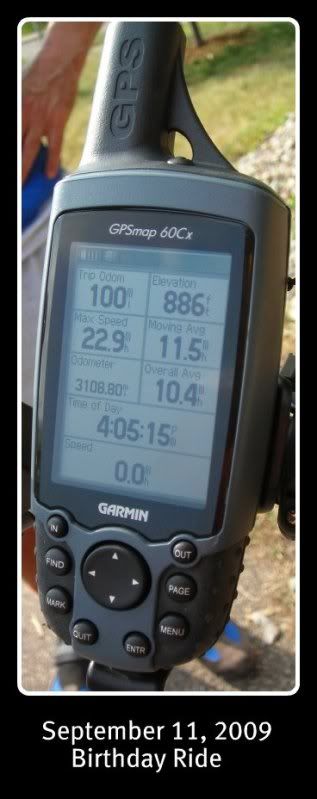
9/11/09 - 104 miles, with the first fifty on the Anura and 54 on my Osell LWB.

My time was under 10 hours for the 100 miles, for an average speed (including rest stops) of 10.4 mph.

Most people who post reports of their century rides have completed them in less than 9 hours, and a lot of riders finish in less than half of my best time. I choose flat routes on local bike paths, loop back to home to change bikes and/or clothes, and -- until this year -- take generous rest breaks.

The century rides started with the realization that my September 11 birthday had lost a lot of its fun value after the terrorist attacks, and I needed to find a different way to celebrate.

Even with the slow times and the easy routes, the accomplishment feels good. And there's always the hope of finishing with a better time next year.

Saturday, July 04, 2009

Fourth of July


We're just back from a 534-mile ride on a 2-trike tandem. We started in northeastern Wisconsin, up by the Michigan border, and rode with the GRABAAWR group along the Wisconsin River as far as Baraboo. At that point, we broke off and followed the 400, Elroy-Sparta, and LaCrosse River trails to LaCrosse, on the Minnesota border.

Today was the Fourth of July, and I rode a 5-trike tandem in the Edina Fourth of July Parade. Two of the other riders couldn't have participated without an option like this -- one was blind, and the other is in her 80's. The other rider carried a puppy on his lap -- not something you could do on a regular bike!

The title bar links to a video clip of several kids taking a ride after the parade.

Sunday, January 25, 2009

Ice Bike Racing - 2009 version


The Minnesota Human-Powered Vehicle Association's 18th Annual Ice Bike Races drew a small enough crowd that I was able to win my class. (No other women showed up -- the only way I ever win these things.) Temperatures hovered just below zero Fahrenheit (minus 18 C), and the ice was rough. It had rained a few times early in the season, ruining the surfaces of most area lakes. Nonetheless, we had a little group of loyal ice bikers and a few spectators when we met on Medicine Lake, just west of Minneapolis. I rode a Greenspeed GTO recumbent trike this year, but the overall winning times were put in by riders on conventional 2-wheelers.

Friday, September 19, 2008

Fastest guy on the planet!!


Sam Whittingham has bicycled at 82.33 miles per hour under his own power and broken the (one-tenth) sound barrier, winning the DeciMach prize. This prize, which has come tantalizingly close to being claimed several times over recent years, celebrates the first human to bike at over one-tenth the speed of sound.

Sunday, September 14, 2008

Infrastructure


When the 35W Bridge fell down in August 2007, it landed on a popular scenic route with bike and pedestrian paths along the Mississippi River. During the reconstruction of the bridge, those paths have remained closed, but for the Tour of Minneapolis bike event on September 14, 2008, cyclists were allowed to ride under the nearly-finished new bridge. We were on a trike tandem, so I was able to photograph the bridge from the back seat.

The Tour of Minneapolis passed under another troubled bridge: the Washington Avenue Bridge between the East Bank and West Bank campuses of the University of Minnesota. Ordinarily, the upper deck of the Washington Avenue Bridge is full of cyclists and pedestrians, but structural deficiencies that were discovered just before classes started for the fall have limited the upper-deck foot traffic to a narrow path down the center.


A small footbridge across the Minnehaha Creek along the Tour route was also gated shut because of crumbling supports, and we passed the Lowry Avenue Bridge -- closed to traffic because of structural inadequacy. We crossed the Mississippi River on yet another bridge with thoroughly-corroded guardrails.

It could have been called the tour of the crumbling infrastructure.

Sunday, August 17, 2008

On the road to Stevens Point -- Osseo to Stevens Point


Bike route 69585 - powered by Bikemap 


The third leg of our ride to Stevens Point was longer than we might have liked -- over 100 miles -- but the time spent laying out a low-traffic route in the hotel the night before was a good investment. We rode south from busy Highway 10 and followed quiet country roads, watching goldfinches and indigo buntings fly up from the ditches, occasionally spotting some sandhill cranes or wild turkeys, and often enjoying the shade of a roadside tree. The downside of the quiet country roads is that they have very few places to eat. We were glad to find a roadside bar and grill just when we thought we couldn't go any further. (Look on the map for a little detour off the road at the location of the restaurant.) The traffic from Highway 10 came to us, because there was a small bridge out on 10, and a detour brought quite a few large trucks to Highway 73, but we were soon able to leave that road and get back onto the smaller ones.

We were pleasantly surprised to find that this route across Wisconsin, despite the detours and construction, was reasonably safe and not too hilly.

On the road to Stevens Point -- Woodville to Osseo, Wisconsin


Bike route 69509 - powered by Bikemap 


On our second day cycling to Stevens Point, we started from Woodville, Wisconsin and rode to Osseo. The day started on quiet roads. At one point, a bald eagle flew across the road, then hunted back and forth along the road just in front of us for a mile or so. We soon found ourselves on Highway 29, which was being resurfaced. We had to wait to ride past the newly-asphalted section, and we were glad to be able to turn south on the Red Cedar Trail. Wisconsin state trails require a trail pass, which we bought in the visitor center. We ate a picnic lunch along the river, then followed the Chippewa River trail to Highway 10. The highway had a paved shoulder that was wide enough for our trike tandem, but it was both less scenic and less relaxed than the country roads, but it was fast and not as hilly as some of the smaller roads. Since we were riding about 80 miles (130 km), we wanted to avoid difficult terrain. In Osseo, we stayed at the Osseo Inn, where we were given a room on ground floor, so that we could bring the trikes inside. We ate pie at the regionally-famous Norske Nook restaurant and planned our long ride for the next day.

Friday, August 15, 2008

Traveling by bike - Europe and the U.S.

I'll come back to mapping our route across Wisconsin, but first a little interruption to write about the differences between cycling in Europe and the U.S. -- or more specifically, cycling in Austria, Germany and the Netherlands versus Minnesota and Wisconsin.

Size: Wisconsin is more than four times the size of the Netherlands and more than twice the size of Austria, and Minnesota is even larger than Wisconsin. Together, Minnesota and Wisconsin are larger than Germany. Population is a different matter: Germany is 82.4 million, the Netherlands 16.5 million, Austria 8.2 million, while Minnesota has about 5 million and Wisconsin about 5.5 million. You have to ride a lot further to get to populated areas and interesting sites in Minnesota and Wisconsin than in Germany, the Netherlands, and Austria.

Routes between cities: except where there are rails-to-trails routes, you are generally on the road in Minnesota and Wisconsin. Only the freeways and a few large highways are forbidden to bikes, but some of the smaller roads are more bike-friendly than others. Wide paved shoulders on many of the roads make cycling with traffic tolerable. The Wisconsin Bike Federation publishes detailed maps with the bike-friendly and bike-unfriendly roads color coded. In the Netherlands and north Germany, intercity routes are on parallel bike trails. In many areas, these are well-labeled and well-maintained. There are some rails-to-trails routes in Germany, and other trails follow old towpaths along the rivers and canals. Austria has the Danube bike route and some other bike paths along rivers and around Neusiedler See, as well as designated bike routes on lightly-traveled roads, but does not have many separate bike trails along the country roads. Where there is a bike path in Germany and the Netherlands, cyclists are generally obligated to ride on it.

Routes within cities: in areas of the Netherlands and northern Germany where bikes are used for transportation, there seems to be an assumption that the rider knows the city. There are directions into town, but once you get there, you often won't find any directions for getting out. Be sure to have good maps and/or a GPS unit. In the U.S. (and in Austria), the edge of town is often car territory, with heavily-traveled streets that have no space for bikes. The green-coded country roads on the bike maps for Wisconsin turn to red around many of the cities, but "urban escape routes" are starting to appear in some areas. Rails-to-trails routes in Minneapolis and St. Paul reach into the center of the cities. City centers in many towns are car-free in these European countries.

Accommodations: the bike-friendly routes through the countryside in Wisconsin require advance planning and packing, because you can ride for dozens of miles without finding any place to eat or sleep. Motels are easiest to find where the small roads intersect the freeways. They generally allow the bikes to be stored in the rooms. Breakfast is usually included with the stay, but it is likely to consist of uninteresting baked goods, coffee, and juice; frequently there is a waffle maker for the guests to use. Internet access is usually free in the small motels across the middle United States, but it doesn't always work. In the Netherlands, northern Germany, and Austria, hotels are much easier to find. Breakfasts are usually generous and tasty. There is likely to be bike parking, often in a secure storage room, but you won't be able to keep the bikes in the bedroom.

Laundry: The biggest barrier to multi-day tours in Austria is the complete lack of coin laundries. You can wash clothes by hand and hang them in special drying rooms in a few bike-friendly hotels, but for the most part you will need quick-drying clothing and some bungee cords to hang them on. Coin laundries still exist in the Netherlands, especially in the large cities. In Wisconsin, we were amazed to find motels with guest laundry facilities -- a large coin-operated washer and dryer; bring lots of quarters!

Monday, August 11, 2008

More about biking Wisconsin


Bike route 65811 - powered by Bikemap 


The first day of our trip to Wisconsin started with the ride from Minneapolis to Stillwater that is seen in the previous post. We stopped for a picnic lunch beside the Stillwater lift bridge, which had just come back into service a couple days earlier. After a long wait for a boat to pass under the bridge, we crossed in slow and heavy traffic. Most of the cars went up the main road, but we took the very steep route up County Road E and then continued quite straight across St. Croix County. After the first big hill, there were a few moderate hills, but nothing really difficult. We would have continued much further east before turning south, but a detour on County Road E led us to change our plans. A small but intense thunderstorm had overtaken us, and we didn't want to explore a detour of unknown length going away from our planned direction of travel, so we changed course. We didn't know where to stay in the little towns north of Interstate 94, but a friendly local cyclist directed us to a pleasant little motel in Woodville, where we could lock the trikes under an overhang directly outside our door. A disadvantage of traveling the quiet country roads in Wisconsin is that there are very few places to eat or sleep along the way. We had packed enough food and drinks, so we didn't go hungry, but we had some worried moments before we located a room for the night.